It's good to see the World Solar Challenge given some publicity eg
http://www.theadvertiser.news.com.au/common/story_page/0,5936,16764301%5E2682,00.html .
This may not be the full story. Xinhua, the official Chinese newsagency, reports an aspect of the winning team' s victory celebrations which you'd normally expect to see featured prominently in many of Mr Murdoch's media outlets:
The Dutch team celebrated in typically exuberant fashion, some members exposing their behinds as the car came to a halt, and later jumping gleefully onto the Victoria Square fountain.
http://news.xinhuanet.com/english/2005-09/28/content_3559543.htm.
What are we to make of this? Who is providing "fair and balanced" reporting here: the Murdoch or the Chinese media?
30 September 2005
29 September 2005
GNE 2005

An outline of my Great Northern Expedition (GNE) in August and September 2005.
Photos - clockwise from top left: On the (unsealed) road again somewhere in the outback; Gregory Downs Hotel (the pub with no beer); Plunge pool Florence Falls Litchfield NP; Getting my feet wet in the Gulf of Carpentaria at Karumba
Day 1: Adelaide - Marree
Early start (by my standards). Rendezvoused with Tony, Coral and their vehicle (1992 Suzuki Vitara wagon similar to mine) then travelled to Quorn where we collected Rolf, Judy and their vehicle (late model Pathfinder).
Headed north. Each of us had a UHF radio but mine had a limited range, so a combination of this and my slow driving meant that we parted company when the others ducked into the Prairie Hotel at Parachilna. I ended up at Marree at dusk, wondering where they had got to. Decided to stay in one of the two caravan parks for the night.
Kms driven: 697.
Day 2: Marree - Tippipilla Creek
Fortunately the lost souls appeared in the morning, having spent the night at Farina some distance back down the track.
We set out along the Birdsville Track, which was in very good nick for an unsealed road. There had obviously been a fair amount of rain recently as there were occasional puddles of water on the road and the grass was tinged with green. We passed a cyclist heading south: he said that he travelled 42 to 92 kms a day depending on which way the wind was blowing.
We stopped at Cooper Creek which, notwithstanding the recent rain, was dry and Mungerannie, where the Derwent River (not marked on many maps) trickled across the road.
Driving on, we stopped for the night on the gibber plain at Tippipilla Creek.
Kms driven: 347.
Day 3: Tippipilla Creek - Birdsville
A relatively brisk run into Birdsville, stopping to inspect the racecourse which was being readied for the annual race meeting.
The town is laid out on a grid pattern and has a good range of facilities including a couple of public internet cafes, a bakery, library and a grassed oval.
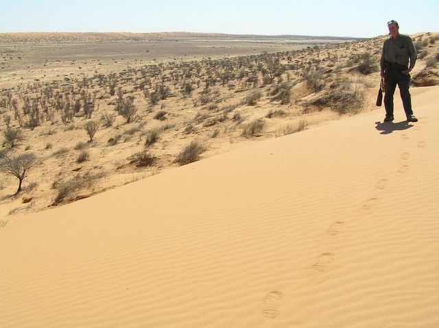
After pitching our tents in the caravan park (I took longer than the others as it was very windy) we drove out to Big Red, reputedly the largest sandhill in the Simpson Desert. Rolf and Tony both drove up it easily. I didn't even try but did climb it (see photo elsewhere on blog).
Kms driven: 264.
Day 4: Birdsville - roadside camp south of Boulia
Drove north on road which interspersed some sealed stretches with unsealed ones. Stopped at Bedourie, another small town with an impressive array of facilities, for lunch, then onwards towards Boulia.
At night camped by a waterhole or river not far from a herd of cattle being driven/ drove (?).
Kms driven: 327.
Day 5: On to Mt Isa
The cattle passed us before we started. We overtook them some way up the road: the motorcycle drovers were moving them along at a good clip.
My car was a bit sluggish so the mechanical experts Rolf and Tony looked under the bonnet and identified a malfunctioning lead as the cause of the problem. They made a temporary repair, which lasted until Boulia when further work was required. Fuel consumption increased significantly during this time (from about 8 to 10 litres/ 100km).
At Boulia we went to the Min Min exhibition a series of graphic exhibits about the legendary Min Min (a bright light which is reputed to appear at random in the district).
From Boulia the road to Mt Isa was sealed, albeit only one lane, which meant that we had to pull over whenever a vehicle approached us.
Stopped at Dajarra, a town which like many in the outback had obviously seen better days, then moved to Mt Isa.
Kms driven: 394.
Day 6: Mt Isa sightseeing
Underground mine
Irish Club
Kms driven: 19.
Day 7: Mt Isa - Adel's Grove (near Lawn Hill)
West along the bitumen towards Camooweal, then north along a road which became unsealed and progressively worse.
Two river crossings.
Riversleigh: disappointing because of lack of signage.
Adel's Grove: camped on the lower level amid rainforest trees. Info leaflet warned of all sorts of creepy crawlies esp snakes but didn't see any.
Kms driven: 334
Day 8: Lawn Hill
Walked, canoed, swam. Idyllic.
At night listened intermittently to cricket. Also heard noise of trucks in background which turned out to be from (relatively) nearby Century mine.
Kms driven: 22
Day 9: Adel's Grove - Gregory River
Back on the rough roads but hit the bitumen again at Gregory Downs, where the pub had no beer for sale on account of licence having been suspended for some unspecified reason.
Camped on banks of Gregory River c 20kms south of pub. Another idyllic site.
Kms driven: 114
Day 10: Gregory River - Normanton
Bitumen most of the way. Stopped to help a young woman whose car had broken down.
Kms driven: 392
Day 11: Normanton - Karumba
Day trip to Karumba.
Kms driven: 191
Day 12: Normanton - Croydon by rail and bus
Gulflander excursion.
Kms driven: 4
Kms travelled: c 300 (roughly half by train).
Day 13: Normanton - Camooweal
Took my leave of the others and headed south, then west. Sealed road all the way so made reasonable time and was able to reach Camooweal, which was better than i expected.
Kms driven: 711.
Day 14: Camooweal - near Daly Waters
Breakfasted at Camooweal Hotel then set off into the Northern Territory: my second visit and each time have entered from Queensland.
A long slog of a drive, not without some interesting sights, though these were generally a long way apart.
Camped overnight in caravan park at junction of Stuart and Carpentaria Highways.
Kms driven: 847.
Day 15: Daly Waters - Birdum
Arrived at Larrimah to join Birdum Alive in 2005 group. Drove with others over a very rough and at times indistinct track to old Birdum site. Pitched tent, looked around, rode to Larrimah Hotel on fettlers' trolley (railway track still in good condition) to replenish liquid supplies.
At night music under the stars.
Kms driven: 115
Day 16: Birdum - Coolalinga
Slow start in morning, despite a good night's sleep, and got back onto the highway at about midday.
Stopped for an hour at Katherine and briefly at Pine Creek and Adelaide River.
Caravan park quite full but I unrolled my swag under a light and went quickly to sleep, disturbed only by a few spots of rain.
Kms driven: 496.
Day 17: Coolalinga - Darwin - Litchfield NP
Drove to Darwin, replenished supplies and then headed south.
Arrived at Litchfield early afternoon, chose campsite at Florence Falls 2WD, drove to Wangi Falls and back, then descended the 135 steps (I counted them) to the plunge pool. Great.
Again early to bed.
Kms driven: 252.
Day 18: Litchfield NP - Tennant Creek
Rose before dawn and surprised myself by getting on the road at 7.06am. I wasn't the only person by any means on the road to the Batchelor turnoff, so I shouldn't be too cocky about the relatively early start.
I set out with an open mind, trying to drive as far as I could in the day (not the night) and expecting to take either three or four days to get to Adelaide. As it turned out I was able without driving too quickly (100 - 110km/ hr) to reach Tennant Creek in the gloaming at 6.30pm.
Kms driven: 985.
Day 19: Tennant Creek - Marla
Another long haul, starting at 7.05 am and finishing at Marla at just before 7pm. Stopped for about an hour in Alice Springs, with briefer halts at Barrow Creek, Ti Tree and Kulgera.
Kms driven: 985 (again).
Day 20: Marla - Adelaide
A very long haul. Arrived home at 9.15pm, having missed only the first session of the final test. I was too tired to watch much more. In retrospect it was a mistake to drive back through the Clare Valley: certainly a much more scenic route (the countryside was very green) but the road was serpentine and each small town necessitated a speed reduction. I'd forgotten how many towns there were in the Clare Valley.
I probably overdid this leg, and while I never came near to falling asleep at the wheel I did stop a couple of times on the last leg and jogged about outside the car to refocus myself.
At no stage during any of the three days did I drink while driving (though a can or two of light beer were most welcome at the end of days 1 and 2).
Kms driven: 1138.
Total trip kms driven: 8624.
Fuel economy: approx 8.2 litres/ 100km (32 mpg).
GNE

28 September 2005
Birdum: the end of the Never-Never line

My interest in the line was aroused by a "Hindsight" program on ABC Radio National http://www.abc.net.au/rn/history/hindsight/stories/s1409442.htm .
I contacted Trevor Horman, President of the Friends of the North Australia Railway, who had contributed to the program. Knowing that I was planning to be in the vicinity (in outback terms) at the time he invited me to Birdum Alive in 2005.
I rescheduled my itinerary and duly arrived at Larrimah, a few kms north of Birdum, where Trevor and everyone else made me feel welcome. We then moved to Birdum for the main event: a combination of field trip, working bee and social function (with live music and other entertainment). The planning and organisation were top quality and I'm sure that everyone there will retain fond memories for a long time. I certainly will.
Unfortunately my camera memory cards didn't have much spare capacity so I couldn't take many photos. The one here shows the end of the line at the former Birdum station site: the track survives and, as we found out, is capable of conveying a well-laden (with people and other supplies) fettlers' trolley to the Larrimah Hotel and back.
The water tower (built in Richmond Victoria in 1929) in the photo is the only surviving structure: the other buildings which constituted Birdum were either dismantled or, in the case of the pub, moved to Larrimah.
25 September 2005
The Captain and the President
I know that there are many links between sport and politics but had never thought that Ricky Ponting had much in common with George Bush. Now a Cambridge academic writing in the London Review of Books has suggested some similarities between the two. See
http://www.lrb.co.uk/v27/n18/runc01_.html .
http://www.lrb.co.uk/v27/n18/runc01_.html .
A new meaning for an old word in the PM's vocabulary?
Insiders (ABC TV) today showed some recent footage of the Prime Minister on talkback radio trying to wash his hands of any responsibility for the current level of petrol prices. In response to an increasingly irate caller the PM replied addressing him as "mate".
This is the first time I recall hearing Mr Howard use the word when he's on the defensive. Is he just following the trend of using it as a generic greeting or is he trying to convince those who returned him to office that he's not lost touch with their hearts and minds, even if he can't do anything about their pockets?
This is the first time I recall hearing Mr Howard use the word when he's on the defensive. Is he just following the trend of using it as a generic greeting or is he trying to convince those who returned him to office that he's not lost touch with their hearts and minds, even if he can't do anything about their pockets?
24 September 2005
Images of India 2005: Mumbai
 VT + PC = CST.
Originally Victoria Terminus, recent changes in the local political landscape have seen the station renamed Chhatrapati Shivaji Terminus, or CST, after a celebrated Maratha warlord. While it is the chief station for the city by no means all intercity trains begin or terminate there, so if you're planning a rail journey to or from Mumbai check your ticket. you may want to think about rebooking if you have to start or finish at an outlying station such as Dadar.
Images of India 2005: Mumbai
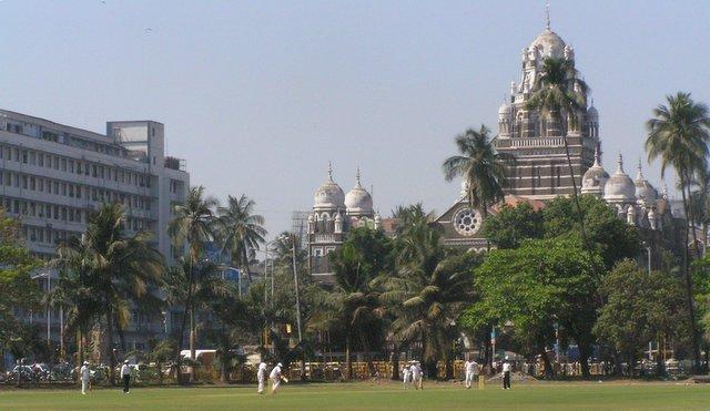 A cricket match in central Mumbai on the Maidan, a large fenced off area with room for several cricket pitches.
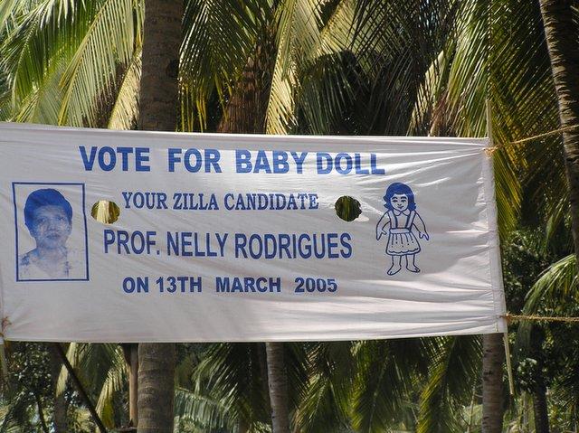
Images of India 2005: Goa

Is this the only bus shelter in the world to
have been given World Heritage listing?
Note the ATM with security guard.
Images of India 2005: Varanasi
 The Ganga at Varanasi.
The city, which is built on one bank of the majestic river, is like a supersized rabbit warren, with narrow lanes which disorient the visitor (and perhaps some residents). Not much seems to have changed since 1956 when Satyajit Ray, the great Indian film director, filmed Aparajito (the second of his Apu trilogy) here. Even the monkeys are still a nuisance: Ray recorded the hazards they presented in his memoir My Years With Apu. By a stroke of good fortune I'd bought a copy just before I arrived and so was able to read what he'd written while looking out from the guesthouse balcony at the passing traffic on the river and the ghats.
Images of India 2005: Jodhpur
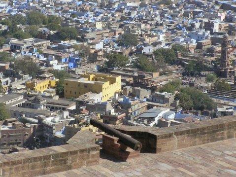 Taken from the ramparts of the Meherangarh Fort, which is a must see (though you need to be prepared for a steep climb to the top). Allow at least half a day to explore what is inside and to look out over the city with its many blue houses and Anglo-Indian style clock tower (on right of photo).
Images of India 2005: Jaisalmer
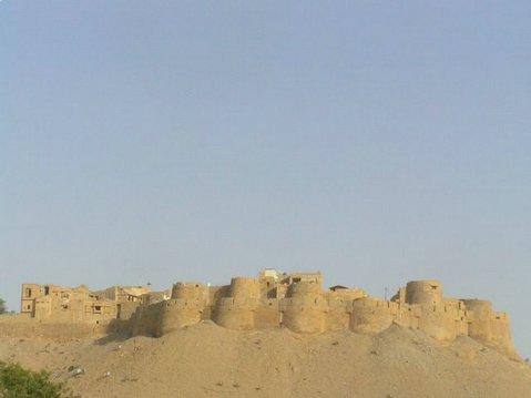 Jaisalmer: currently accessible only by road and rail (the latter is less stressful) but worth a visit to see this fort.
20 September 2005
Subscribe to:
Posts (Atom)
